Shyamali Basu

Mizoram


Mizoram, nestled in the picturesque and gentle hill folds situated between Manmar and Bangladesh. Mizo people have blended themselves in the changing landscape to suit into it. Front door of their houses are built in the strret level. The back of the house stands on stills fascinatingly in an unreal balance. Mizos love flowers. 87% are Christian. Their hospitality is world renowned.


Area : 21,087 Sq Km.

Capital : Aizawl.

No. of Districts : 8

Season : October to March.

Access : Nearest Rail Head, Silchar – 180 Km from Aizawl.

Lengpui Air Field in Aizawl is connected by Indian Airlines and offer daily service from Kolkata.

Guwahati {easily accessable by both Air and Rail}is 420 Km ffrom Aizawl.

Entry Formalities : Domestic tourists can obtain Inner Line Permit from Liason Officer posted in New Delhi, Kolkata, Guwahati, Silchar and Shillong. Two passport sized photograph and a photocopy of Identity proof [Voter ID/PAN Card/ Driving License] are to be attached with the prescribed application form.

Entry Formalities for foreign tourists : For a group of 4 or more – Resricted Area Permit {RAP} may be obtained from the Govt of Mizoram thorough Liason Officer posted in New Delhi, Kolkata, Guwahati, Silchar and Shillong.

For less than four – RAP can be obtained from Ministry of Home Affairs, Govt of India, New Delhi.


Place of visit :

Aizawl – Bung Picnic spot – 15 Km on a hill, Tamdil Lake – 85 Km, Vantawng water falls, Reiek Tourist Resorts – 35 Km.

Champhai – Mura Peak – a cluster of 6 men inside caves curved out of solid rock {6 Km}, Kungawrhi Park , Tian river in the boundary of India and Myanmar.

Rihdil Lake – Inside Myanmar but permission is easily obtainable from the Deputy Commissioner’s office at Champhai.

Ngengpui Wildlife Sanctuary 296 Km., Tawi Wildlife Sanctuary – 101 km.


Shyamali Basu

Meghalaya

Meghalaya is overwhelmingly beautiful, where everything is impossibly green and alive. The rolling mists in the valleys , the undulating hills, numerous lakes, water falls, caves, dense forests and exotic flora and fauna together with the unique tribal culture makes Meghalaya a unique and interesting destination.


Area : 22.429 Sq Km.

Population : 23,18,822 {2001 Census}

Capital : Shillong.

Season : Throughout the year.

Clothing : In winter heavy woolen, light woolen for the rest of the year.

Access : Umroi is the nearest Airport – 35 Km from Shillong but there is no regular flight. Guwahati {103 Km} from Shillong is the main entry point both by Air and Rail. Regular bus and car service available from Guwahati to Shillong.


Place of Visit.

Shillong : State capital, picturesque landscape, Wards Lake, Lady Hydari Park, Sweet falls, Elephant falls, Golf course, view point, St Cathedral church, tagore’s residence etc.

Cherrapunjee : 54 Km from Shillong. Ram Krishna Mission, falls,ECO park, Green rock ranch etc.. It was famous for the highest rainfall in India in the past but now Mawsynram in the same state has snatched the credit.

Mawphlang Sacred Groves : 24 Km from Shillong.

Smit : Cultural seat of the “Khasi”, the local habitats.

Mawsynram : 56 Km from Shillong. Cave known for the giant stalagmite and stalactite formation in the shape of Shivalinga. Maximum rainfall in the country is recorded here.

Jakrem : 64 Km from Shillong, famous for hot spring of sulphar.


Shyamali Basu

LAHAUL AND SPITI

Best season : June to October.

Clothing : Heavy woolens.

Access : By road from Manali. Delhi – Manali 490 Km.

Airport : Kulu.


After leaving behind the lash green meadows and orchard of the Kulu valley, the change in the landscape is dramatic and the road is one of the highest highways in the world – descends from the Rotang Pass {3980 Mtr} into a landscape of bare hills, steep ridges, cliffs of bare rock, deep ravines and villages.strewn with the moraine left behind by residing glaciers. Little villages with their patchwork of green fields, located near gushing streams, provide colour and relief to this rather forbidding landscape.


Lahul with it’s curious mix of Buddhism and Hinduism has find gompas and temples. Gomphas  of Lahul’s reach store of Buddhist art and culture and focus of social activity and festivity of the region.


Spiti – High altitude cold desert – land of fairy tales and fantasy. Stark range that seem painted in shades of russets, purple and pink, eroded mountain – strewn stream with bolders, deep gorges curved out by swift flowing snow-fed and streams. Small villages with box – like house in the river valleys that stand a mid lash fields and groves of juniper, poppler and willow during summer and blanketed with snow during the rest of the year. It has 30 monestries with rich Buddhist culture.


Place of visit at Lahul

Gomphu – 67 Km from Manali from where a branch of road went to Kunjum Pass and Spiti.

Koksar {3140 Mtr}- North of Gomphu, coldest place in Lahul.

Tandi – 94 Km from Manali. Confluence of Chandra and Bhaga river.Guru Ghantal monestry is located high above Tandi.

Keylong {3350 Mtr}- A rough cut emerald in bronze and silver setting. The green of it’s fields, with willows popler planted along water courses, make a patch of brillian colour against the bare hills. A number of important Gumphas are located here.{Kharding Monestry – 35 Km.}. Kelong is 102 Km from Manali.


Please visit Triloknath and Udipur while in Keylong. Also visit the temple of Marikula – 166 Km from Manali.


Place of visit at Spiti

Kunjum Pass – gateway of Spiti from Manali. Altitude 4590 Mtr.

Kaza – A little of deeper along the valley is Kaza, noted for it’s historic Kyi Gompha.- located 11 Km from Kaza{4160 Mtr}. Splendid monestry – a cluster of white flat roofed structure high up on a hill very much like a fort. 14th century breathes taking murals and a valuable collection of KANGYUR – ancient Buddhist text.

Losar – 60 Km from Kaza. Confluence of Losar and Peeno streams.

Attergu – Access to the Pin valley. Kungri Goompha is located here, On the left Lingti valley.

Shchichuling – 50 Km ahead Sumdo. Famous Dhankar Monestry – rich in interesting murals and stuccos is located here.

Tabo – 3050 Mtr. On the lft bank of river Spiti, surrounded by high mountains. 1000 years old Tabo gumpha is located here, established by the legendry Rinchen Tsangpo – next of Tholing Gumpha in Tibet – priceless collection of manuscripts, thangkas, murals and painted stucco.

Sumdo – Entry point of Spiti from Kinnaur.


Tour Packages : Add extra 3 days for Lahul and 3 days for Spiti.


Shyamali Basu

Uttaranchal : Garhwal Region

Capital : Dehra Dun.

Area     : 55,845 Sq Km.

Population        : 84,79,562 {2001}

District : 13


Garhwal Region

Altitude : Yamunotri {3165 Mtr}, Gangotri {3042 Mtr.}, Kedarnath {3581 Mtr}, Badrinath {3133 Mtr}

Season : April to November.

Clothing : Summer – Light Woolen

                 Winter – Heavy Woolen.

Airport : Jolly Grant , Dehradun

Rail Head : Hardwar, Dehradun, Rishikesh.

Accommodation : Tourist Rest House, PWD Inspection Bungalow,Forest Rest House, Dharamsala and Private Hotels.


Distance by road                                              KM     


Hardwar                       Rishikesh                      24

Hardwar                       Dehradun                     52

Dehradun                     Mussourie                    38

Rishikesh                      Hanumanchati               210

Rishikesh                      Gangotri                       249

Rishikesh                      Gourikund                    215

Rishikesh                      Badinath                       301

Rishikesh                      Chopta                         236

Hanumanchati               Gangotri                       210

Gangotri                       Gorikund                      348 {Via Rudraprayag,Srinagar}

Gourikund                    Badrinath                      250 {Via Rudraprayag}


Tour No1 : “Chardham Yatra” [Yamunotri-Gangotri-Kedarnath-Badrinath]

Dehradun-Kempty Falls-Syanachati-Hanumanchati-Jankichati{By bus/car}{1}-6 Km Trek to Yamunotri-6Km trek to Jankichati{2}-Uttarkashi{3}-Gangotri{4}-Uttarkashi{5}-Rudraprayag{6}-Gourikund{7}-14 Km trek to Kedarnath {8 and 9}-Gourikund{10}-Ukhimath via trijugunarayan{11}-3 Km trek to Tungnath via Chopta {12}-Joshimath {13]-Badrinath {14 and 15}-Hardwar{16}

Tour No.2 : Kedarnath and Badrinath.

Hardwar/Rishikesh-Gourikund{1]-14 Km trek to Kedarnath{2 and 3}-14 Km trek to Gourikund{4}-Ukhimath via Triyuginarayan{5}-Tungnath via Chopta{6}-Joshimath{7}-Badrinath{8and 9}-Hardwar{10}

Tour No.3 : Yamunotri and Gangotri

Hardwar/Rishikesh-Jankichati{1}-6Km trek to Yanunotri-6Km trek to Jankichati{2}-Uttarkashi{3}-Gangotri{4and 5}-Hardwar/Rishikesg{6}

Tour No.4 : Ganotri to Tapaban via Gomukh

Gangotri-14 Km trek to Bujbasa-{1}-5Km trek to Gomukh-6Km trek to Tapoban{2}-11Km trek to Bhujbasa{3}-14 Km trek to Gangotri {4}

N.B. : Horse/Pony/dandy/kandi available in the route. For Tapoban, guide is compulsory.10 to 12 person’s accommodation is available at Tapoban, It is preferred to carry own tent for safety.

Tour No.5 : Dehradun/Mussourie.

Hardwar-Rishikesh{1 and 2}-Dehradun-Mussourie{4and 5}-Haridwar{6}

Tour No.6 : Pancha Prayag

Haridwar-Devaprayag{Ganga and Alakananda}{1}-Rudraprayag{Alakananda and Mandakini}{2}-Karnaprayag {Alakananda and Pindar}{3}-Nandaprayag{Alakananda and Nandakini}{4}-Bishnuprayag{Alakananda and Dhauliganga{{5}-Haridwar{6}

Tour No.7 : Panchakedar

Haridwar_Gourikund{1}-Kedarnath{2}-Gourikund{3}-Rashu via Ukhimath{4}-trek to Madmaheshwar{5}-Ukhimath{6}-Trek to Tunganth via Chopta {7}-Trek to Anusua via Mondal {8]-17 KmTrek to Rudranath{9]- 22 Km Trek to Mondal/Sagar{10]-12 Km Trek on the way to Joshimath{11 and 12}- Hardwar{13}


Place of Tourist Interest.

Dehradun  : Sahasradhara, Sulpher water spring,Tapkeshwat Temple,Cave Temple of Lord Shiva,Dronacharya Ashram,Malsi Temple, Sai Darbar, Deer Park.

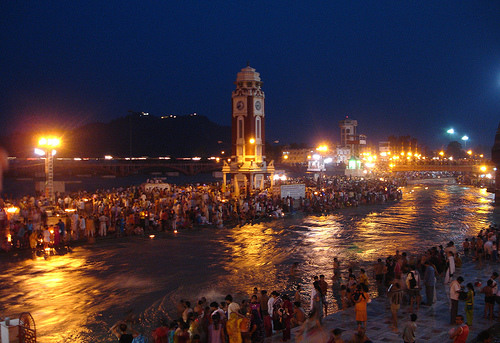
Hardwar : Har ki Pauri, Bhimgoda, Hanuman Temple, Bharat Mata Mandir, Parmarth Ashram,Mansa Devi Temple {Ropeway}, Chandi Devi Temple.

Mussourie : Is known as queen of hills, Gun Hill, Kempty Falls, Lal Tibba, Sukhanda Devi Temple..

Lakha Mandal : 75 Km from Kempty Falls. It is believed that Kauravs conspired to burn Pandavs here.

Rishikesh : Bharat Mandir, Rishikund,Gita Bhawan, Laxman and Ram Jhula.

Yamunotri : Temple, Divya Shila,surya Kund hot spring.

Gangotri : 18 century white granite temple of Ganga devi, submerged Shivling.

Uttarkashi {1150Mtr} : Viswanath, Ekadash Rudra, Gyaneshwar and Kuteti Devi Temple, Nehru Inst. Of mountaineering.

Gomukh : Snout of Gangotri glacier.

Harshil {2620 Mtr} : Scenic landscape and Sat Tal {2Km} on the way to Gangotri.

Tapovan : Base camp of Bhagirathi Peak, Panoramic view of Shivalik peak, beautiful meadows.

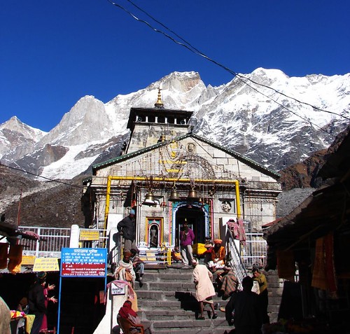
Kedarnath : The oldest Jyotirlingam of 8th century.

Vasukital : A picturesque lake, 6km trek from Kedarnath.

Triyuginarayan : It is believed that Lord Shiva and Parvati was married here, the sacred flame is still visible here.

Gupta Kashi : The temple of :Ardhanarishwar” and Viswanath.

Ukhimath : Known as second Kedar, Winter resort of deity Kedarnath and Madmaheshwar.

Chandrashila : 1 Km trek from Tungnath, Alpine meadow with rare view of snow clad peaks.

Tungnath : 3 Km trek from Chopta, Known as third Kedar, Shiva’s arm is worshipped here.

Badrinath : On the bank of river Alakananda the temple of Sri Badrinath, also known as Badri Vishal.

Sita Kund : Hot water spring on the foot hill of thee temple of Badri on the basin of Alakananda.

Mana Village : 4 km from Badri Temple, the last Indian village famous for Vyas and Ganesh cave,.

Valley of folwer ; 19 Km trek from Govindghat. National park with plenty of flowers, paradise of nature lovers.

Hemkund Sahib : A famous Gurudwara on the way to Valley of Flowers. Both Hindu and Shikhs visit this shrine. Guru Gobind Singh is believed to be unified with God here.

Joshimath : One of the four maths established by Adi Guru Shankaracharya.

Auli ; Ideal ski resort of Garhwal Himalayas, offers a magnificent views of Himalaya range.

Pauri : A picturesque spot at the altitude of 1850 Mtr.A dream location within pine forest and apple orchard.

Rudranath : Known as fourth Kedar, Shiva’s face is worshiped here. A very tough trek of 22 Km from Sagar. Altitude of 2286 Mtr.

Kalpeshwar : Known as fifth Kedar. A small rock temple at an altitude of 2134 Mtr.